Spatial data available in the intensive regions
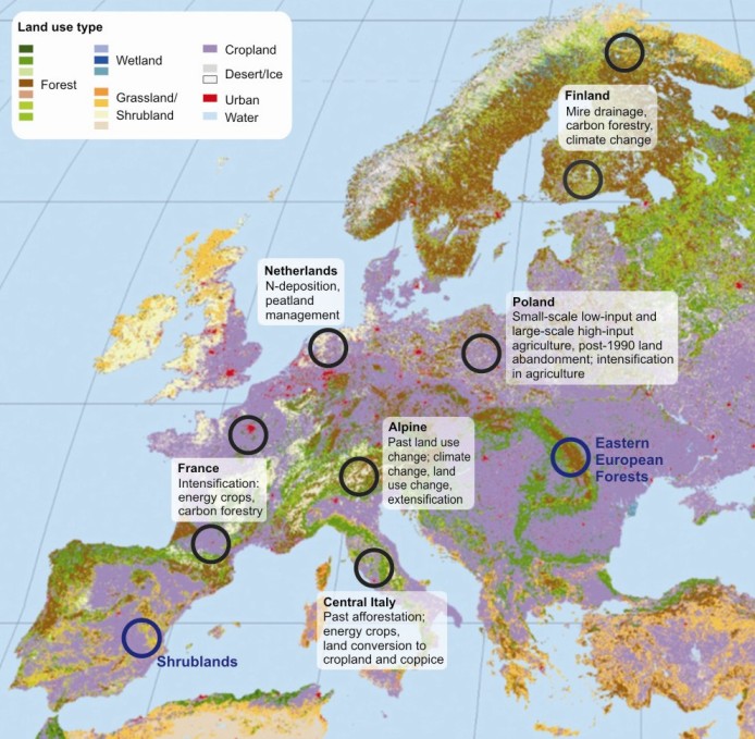
With the aim to provide data-rich case studies and observational evidence of regionally coherent changes in drivers and of ecosystem response six data rich regions have been selected representing a wide range of different soils, land use history, climatic conditions and socio-economic background, as well as differences in trends in land use response to changing policies and markets.
The six regions are reported in the figure below and high resolution spatial data in addition to ecosystem fluxes are available for each area. The data are under collection and will be distributed in standard format here together with detailed metadata.

Alps
| Variable | Description | Resolution | Period | Download |
| Land use | CORINE Land Cover (CLC) | - | 1990 | Get it |
| Forest inventory data | LFI / SFI (Swiss Forest Inventory) | | | Get it |
Central Italy
| Variable | Description | Resolution | Period | Download |
| Soil | Soil texture, carbon, depth and pH | 1km | | Get it |
| Meteo | SWin, LWin and Surface T (from MSG) and Precipitation. Available directly by FTP, please contact the database for use and questions | 5km - hourly | 2010-2012 | Get it |
| Land Use | CLC2000 Level4 | 1km - annual | 2000 | Get it |
| Land Use | Cropland species geo-referenced DB | vec - annual | 1995-2010 | Get it |
| Land Use | Wheat and crimson clover map | 50m - annual | 2000, 2009 | Get it |
| Management | DB of crop management practicies | - | 1997-2007 | Get it |
| Land Use Change | LUC shape and database based on photo-interpretation | vec - 4 periods | 1954-90-99-2009 | Get it |
| Management | Forest harvesting and age maps | 50m - annual | 2004-2008 | Get it |
| Airborne images | Spectral data at high resolution at 7 Eddy sites - Rocca forest, Rocca crop, SRF cluster. More... | 0.1-5m - July and August | 2011 | Ask |
Finland
France
| Variable | Description | Resolution | Period | Download |
| Soil Organic Carbon | Map of organic carbon stocks for the first 30cm for mineral and organic-mineral soil horizons (stocks in kg/m2, projection is LambertII extended). These stocks do not include surface organic horizons. The methodology is strictly the same as in the publication mentioned bellow, except the facts that the land use dataset used for prediction (EcolclimapII) is different and the RMQS dataset used for fitting the models has been completed since the paper has been published. This publication should mentioned when using this SOC stock map. Martin MP, Wattenbach M, Smith P, Meersmans J, Jolivet CC, Boulonne L, Arrouays D. 2011. Soil organic carbon stocks distribution in France. Biogeosciences, 8: 1053-1065. | 2.5km | 2000 | Get it |
Netherlands
Poland